
20.1. Atmospheric Stability#
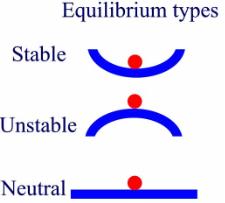
The stability of the atmosphere can be described using the three different conditions of equilibrium: stable, neutral, or unstable (Fig. 1). When a ball is displaced up either side of a valley, gravity will work to bring the ball back to its starting point. This would be described as a stable system. If the ball was on top of a ridge, any displacement would cause the ball would move quickly away from its initial point - this is defined as an unstable system. Finally, when a ball is displaced and does not act to return to its original starting position or move farther away from the original starting point, the stability would be defined as neutral.
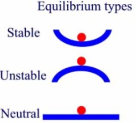
Fig. 20.1 Different conditions of equilibrium related to stability. Image from the Equilibrium, Stability, and Behavior over time and is licensed under the “Creative Commons Attribution-Share Alike 4.0 International”. Image source https://serc.carleton.edu/images/introgeo/models/Stability.jpg.#
These conditions can also be applied to the atmosphere. For parcels initially displaced upwards, those wanting to rise without any forcing would be unstable; those wanting to sink would be stable; those that would need more forcing in order to rise freely would be conditionally unstable; all others would be neutral. We will now apply these equilibrium types to the atmosphere and use parcel theory to determine the stability of the atmosphere.
Parcel Theory#
In meteorology, parcel theory is used to determine and describe the stability of the Earth-atmosphere system. A parcel is a fictitious blob of air that has similar moisture and temperature characteristics throughout the parcel. Parcel sizes vary from the size of a large playground ball to as big as a parking lot. To envision what parcels may look like you could think of the bubbles in boiling water or the blobs of wax that move up and down in lava lamps. The mechanisms in the atmosphere are similar to both of those examples; a parcel of water or wax is heated from below, just as the sun heats the atmosphere from below.
Whether the atmosphere is stable, unstable, or conditionally unstable, rising motion can occur and lead to the development of different types of clouds. The development of clouds is predicated on the fact that there is sufficient moisture to go along with the rising motion. In stable layers with sufficient moisture and rising motion, sheet like clouds will form (e.g., stratus, altostratus). In unstable or conditionally unstable portions of the atmosphere with sufficient moisture puffy clouds (e.g., cumulus, cumulonimbus) often form.
When air parcels rise, they always, and for all time will, cool. Depending on the exact atmospheric conditions, the parcels will cool at one of two lapse rates. If the air is not saturated (< 100% RH; unsaturated) then rising parcels will cool at the Dry Adiabatic Lapse Rate (DALR) of 9.8 \(K\) \(km^{-1}\). For parcels with 100% RH, if they continue to rise, will cool at the Wet Adiabatic Lapse Rate (WALR), also known as the Moist Adiabatic Lapse Rate (MALR). The WALR is not constant and varies greatly over the temperature and pressure profile; consult a skew-T/log-p diagram to confirm this fact.
WALR vs. DALR#
The WALR is actually not an adiabatic process. Adiabatic motions are such that there is no net gain or loss of energy; the change in temperature comes through the expansion (cooling) or compression (warming) of parcels. If you continue to cool air that is already saturated, according to the Clausius-Clayperon equation, less water vapor can be present in cooler air, so it must be converted from water vapor to liquid water or ice. This is one way in which clouds are formed. So air parcels are still rising and cooling at the DALR, but when the water vapor is converted to liquid water, latent energy is released to the air parcel, which will slightly warm the parcel. This results in a slightly lower cooling rate for a saturated parcel.